
Quick Read
- A Polar Vortex collapse and split is confirmed for mid-February 2026.
- The event is triggered by a significant Stratospheric Warming (SSW) event.
- Prolonged cold weather patterns are expected across North America and Europe.
- Temperatures in parts of the U.S. are already dropping 30°F below normal.
- The cold patterns are forecasted to persist into early March 2026.
WASHINGTON (Azat TV) – New forecasts definitively confirm a significant Stratospheric Warming (SSW) event is set to trigger a full Polar Vortex collapse and split by mid-February 2026. This atmospheric shift is expected to usher in a prolonged period of exceptionally cold weather across vast swathes of North America and Europe, with effects potentially lingering into early spring.
While the main collapse is anticipated in the coming weeks, parts of the United States and Canada are already experiencing early disruptions from an elongated Polar Vortex, pushing cold air anomalies into central and eastern regions. Forecasters indicate temperatures in some areas could drop more than 30°F below normal, signaling the initial stages of a complex and impactful weather pattern.
Mid-February Stratospheric Warming to Drive Collapse
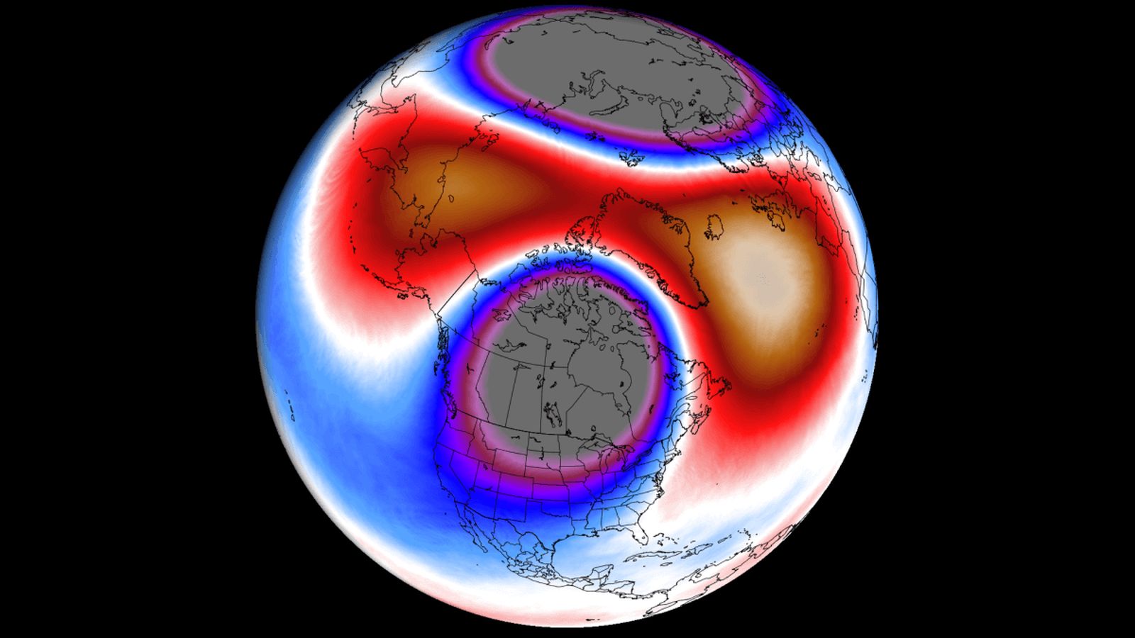
The Stratospheric Warming event, which serves as the primary catalyst for the Polar Vortex disruption, is projected to begin unfolding over the next 8 to 10 days, peaking around mid-February. This phenomenon involves a rapid rise in stratospheric pressure and temperature, which significantly stresses the Polar Vortex, causing it to weaken, elongate, or even split into multiple cores. Data from `Severe Weather Europe` indicates a clear and continuous weakening of the stratospheric Polar Vortex, with winds approaching a full reversal, a hallmark of a strong SSW event.
Latest analyses at the 10mb level (approximately 30 kilometers high) reveal the formation of two strong stratospheric high-pressure areas, accompanied by an intense warming wave. This configuration is directly responsible for splitting the Polar Vortex into two distinct cores. Temperature anomalies in the mid-stratosphere are projected to soar over 50 degrees Celsius above normal over the polar regions, underscoring the severity of this particular warming event.
Understanding the Polar Vortex and Its Disruption
The Polar Vortex is a vast, spinning circulation of cold air that extends from the Earth’s surface into the stratosphere, trapping frigid air over the polar regions. It comprises two main layers: the lower, tropospheric part and the higher, stratospheric part. A strong Polar Vortex typically contains this cold air tightly, resulting in milder winters for mid-latitude regions like the United States and Europe.
However, when the Polar Vortex is disrupted by events such as an SSW, its ability to contain the cold air diminishes. The vortex can elongate, deform, or split, allowing the frigid polar air to spill southward into lower latitudes. This is precisely what forecasters confirm is underway and will intensify by mid-February. The current deformed state is already pushing arctic airmasses into North America, leading to significant temperature drops and winter storm conditions.
Widespread Cold Expected Across Continents
The impending collapse is set to bring widespread cold. In North America, the eastern United States and eastern Canada are expected to bear the brunt of the cold pattern. Regions from Washington, D.C., Maryland, Delaware, New Jersey, the New York City metro area, Connecticut, and Rhode Island are particularly susceptible to sustained freezing temperatures, according to `PhillyBurbs.com` and other forecasters. The National Oceanic and Atmospheric Administration (NOAA) Winter Storm Severity Index predicts major to extreme impacts over large parts of the Carolinas from an incoming polar airmass.
Europe will also experience a significant influx of cold air, primarily descending from the north. While a low-pressure system in western Europe may temporarily moderate temperatures in central and western parts, the continent’s northwestern and northern regions are expected to face substantial cold. This cold potential across both continents is consistent with historical responses following strong Stratospheric Warming events, which typically lead to a delay of 10-30 days before surface impacts become fully apparent.
Long-Term Outlook: Persistent Cold into Spring
Looking ahead, the forecast indicates that the disrupted weather circulation will persist well into early March. Ensemble models show a continued pattern of high-pressure blocking over the polar regions and Greenland, coupled with low-pressure systems extending from the United States across the Atlantic to Europe. This pressure configuration is a clear signature of a collapsed Polar Vortex and is expected to maintain northerly flows, continuing to deliver cold airmasses to affected regions.
Extended-range temperature forecasts from the ECMWF ensemble show below-normal temperatures persisting over western Canada, serving as a source region for cold air that will subsequently be released into the United States. Similarly, a cooler trend is projected for a larger part of Europe into early March. While these are extended-range forecasts, focusing on broad pressure anomalies rather than precise daily temperatures, they provide high confidence in the development of a textbook weather response to the confirmed stratospheric warming event across the Northern Hemisphere.
The confirmed Stratospheric Warming event and subsequent Polar Vortex collapse represent a significant and well-understood atmospheric phenomenon with predictable downstream impacts. The consistency across various forecast models provides strong confidence that North America and Europe are entering a period of prolonged cold, marking a notable end-of-winter weather pattern.