
Quick Read
- A rare early Sudden Stratospheric Warming event is forming over the Arctic in November 2025.
- The polar vortex is expected to weaken, releasing cold Arctic air into North America and possibly Europe.
- Forecasts predict colder temperatures and significant snowfall across the U.S., Canada, and parts of the UK.
- European weather models show uncertainty but warn of potential cold surges.
- Meteorologists advise close monitoring as winter patterns could shift rapidly.
What Is Sudden Stratospheric Warming and Why Does It Matter?
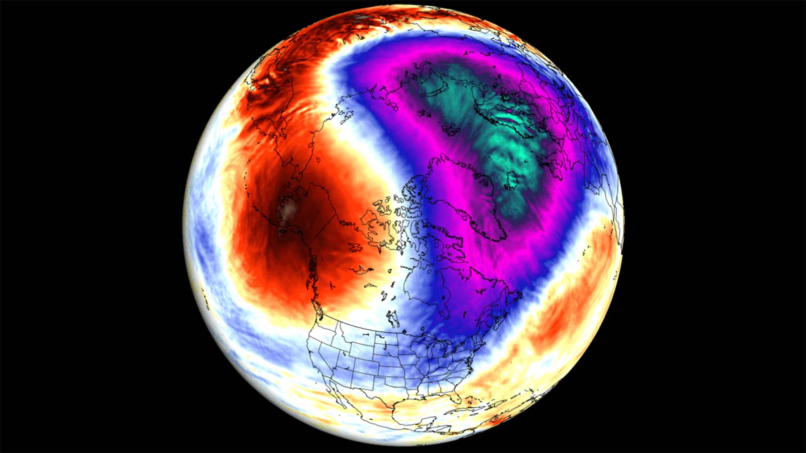
Every winter, meteorologists keep a close watch on the upper reaches of our atmosphere for a phenomenon that can flip the seasonal script: Sudden Stratospheric Warming (SSW). In late November 2025, forecasters from NOAA, Severe Weather Europe, and others are sounding alarms about a powerful SSW event forming over the Arctic. This rare occurrence is set to disrupt the polar vortex—a sprawling mass of cold air swirling above the North Pole—potentially unleashing a cascade of winter weather surprises across the Northern Hemisphere.
But what exactly happens during SSW? The stratosphere, the atmospheric layer just above where weather happens, suddenly heats up by tens of degrees Celsius—sometimes as much as 40°C above normal. This spike in temperature weakens or even splits the polar vortex. When the vortex is strong, it corrals frigid air over the poles. When it falters, that cold air escapes southward, intruding into regions that might otherwise expect milder winter conditions.
Forecasts for Late November: The Vortex Under Siege
Models from the European Centre for Medium-Range Weather Forecasts (ECMWF) and GFS paint a dramatic picture for late November 2025. High-pressure systems—sometimes called ‘anti-vortices’—are expanding in the stratosphere, aiming straight at the vortex. By November 26, the disruption is expected to peak. This could collapse the polar circulation, setting the stage for widespread cold snaps and snow events.
Ensemble runs from these leading weather models show significant warming at the 10 hPa level, a key altitude for monitoring stratospheric shifts. Analysts like Andrej Flix at Severe Weather Europe note, “Forecasts show a collapse of the polar circulation in the second half of the month, with cold weather and snow to follow across the United States and Canada, but with less clear impacts over Europe for now.”
Historically, SSW events tend to push cold Arctic air southward within one to three weeks, meaning the impacts could hit in early December and linger through the holidays.
Impacts Across North America: Snow, Cold, and a White Christmas?
For the United States and Canada, the implications are already coming into focus. El-Balad and Watchers.News report that the northern and central U.S. are bracing for a robust discharge of Arctic air as the vortex weakens. Forecasts suggest extensive snowfall, particularly in northern and western regions, and sustained below-average temperatures into late December. The possibility of a white Christmas is higher than usual, especially as cold air collides with incoming moisture from the Atlantic and Pacific.
Airline passengers and crews on high-latitude flights could experience increased radiation exposure due to elevated proton flux, as noted by the NOAA Space Weather Prediction Center. Satellite operations and radio communications—especially near the poles—may face minor disruptions, though the greatest impacts will be felt on the ground, where cold air and snow pose more immediate challenges.
Europe: Uncertainty and Potential Cold Surges
Across the Atlantic, the picture is more nuanced. The UK’s Met Office and reporting from Mirror.co.uk highlight a transition from mild, rainy weather to a colder, drier regime. By the weekend and into the second half of November, much of the UK will fall under cooler air masses, with overnight frosts and, on higher ground, the potential for snow.
Maps from WXCharts show temperatures dipping to -7°C in Scotland, -3°C in northern England, and -2°C in the south by midweek. While southern regions may see lingering clouds and occasional rain, the trend is toward colder, clearer conditions for most. The timing and extent of snow remain uncertain, but the groundwork is laid for a wintry spell—especially if the polar vortex continues to weaken.
Europe’s outlook is complicated by model divergence. While some ensemble members predict significant cold intrusions, others suggest a milder pattern. The persistent high-latitude pressure anomalies, however, keep the door open for a negative Arctic Oscillation—a setup that typically favors cold, snowy conditions.
Atmospheric Science: Why Early SSW Matters
Stratospheric warming events are not just meteorological curiosities—they can reshape an entire season. Early SSW, like the one developing now, is especially influential. It occurs before winter patterns are fully established, allowing the disrupted vortex to steer cold air and snow systems into places that might otherwise escape severe winter weather.
NOAA’s stratosphere–troposphere monitoring and the Met Office’s seasonal guidance both point to a moderate to high probability of continued disruption, though these are probabilistic, not definitive. As Rishav Kothari from Watchers.News writes, “Persistent high-latitude pressure anomalies and cross-model alignment suggest a significant stratospheric shift is likely before the end of November.”
If the warming continues, North America is in line for an extended period of cold and snow, while Europe waits to see just how far the Arctic’s influence will reach.
Looking Ahead: Monitoring the Polar Vortex
The coming weeks will be critical. Meteorologists will monitor temperature anomalies, pressure systems, and the configuration of the polar vortex. Will the warming pulse collapse the vortex completely, or will it merely nudge cold air southward for a brief spell?
For now, the consensus is clear: an early SSW is unfolding, and its effects are likely to be felt well into December. Communities across the Northern Hemisphere should prepare for colder, snowier weather—and stay tuned as scientists track the evolving atmospheric drama above the Arctic.
The onset of an early Sudden Stratospheric Warming in November 2025 stands as a striking reminder of the interconnectedness of Earth’s atmospheric systems. The disruption of the polar vortex not only redefines seasonal expectations but underscores the value of close scientific observation. As models converge on a colder, snowier outlook, one lesson rings clear: our understanding of winter hinges on the invisible forces shaping the skies far above.