
Quick Read
- Monsoonal rain is causing daily rainfall of 100–200mm in northern Queensland, with isolated areas expecting more.
- Flood warnings and watches are in effect, with major rivers at risk and communities preparing for possible isolation.
- Travelers are urged to check road closures and follow safety advice as conditions change rapidly.
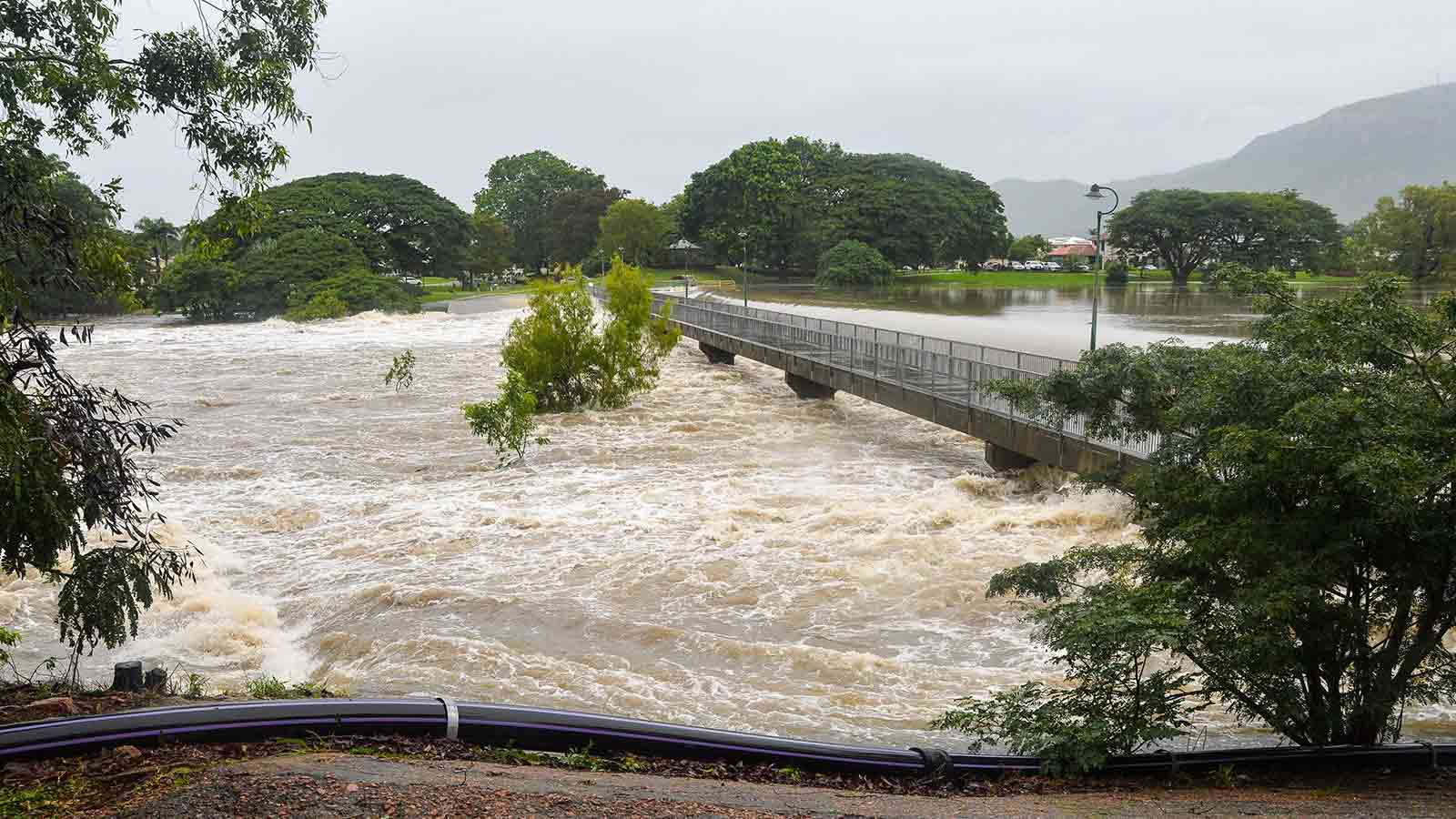
As 2025 draws to a close, northern Queensland finds itself under siege from relentless monsoonal rains and the looming threat of widespread flooding. With the Bureau of Meteorology (BOM) warning of potentially ‘protracted flood events’ into next week, communities across the state’s north-west and north-east are bracing for a turbulent end to the year.
Rainfall began intensifying over the weekend, with meteorologists forecasting daily totals of 100 to 200 millimetres—and in some isolated areas, even more. According to senior forecaster Felim Hanniffy, ‘widespread shower and storm activity’ is expected to drench the northern half of Queensland, while parts of the north-west and Gulf regions could see daily accumulations exceeding 200 millimetres.
Seven-day rainfall totals have already surpassed 200 millimetres in some locations, saturating catchments and setting the stage for dangerous flash flooding. The BOM has issued severe thunderstorm warnings for the north tropical coast, including Townsville, and flood watches cover much of the north-west, where communities are preparing for the worst.
Local Resilience and Concerns
In Mount Isa, a town familiar with the cycles of Queensland’s wet season, the mood is one of cautious readiness. Mayor Peta MacRae described a community ‘watching and waiting,’ noting that while rain had started lightly, heavier falls were expected to arrive soon. Supplies are being stocked, and residents remain prepared for the possibility of being cut off, a scenario not unfamiliar to them.
Mount Isa District Acting Superintendent Paul Austin underscored the need for vigilance, particularly among graziers and property managers, who must contend not only with flooding but also with a sharp drop in temperatures—potentially more than 12 degrees Celsius below average. This chill, driven by easterly winds, poses risks to livestock, especially in light of past weather events that have resulted in significant cattle losses. However, Cr MacRae expressed hope that the region would avoid a repeat of the devastating 2019 floods, citing better cattle conditions and lower stock numbers this year.
Nearby Cloncurry has already felt the impact, with 120mm of rain recorded in just 24 hours. The State Emergency Service responded by distributing sandbags, and flood warnings have been issued for the Flinders, Cloncurry, Norman, and Gilbert Rivers, reflecting the scale of the threat.
Travel Disruption and Safety
For holiday-makers and locals alike, the message is clear: check road closures before setting out, and heed the advice, ‘If it’s flooded, forget it.’ Rolling road closures have affected travel across the region, with conditions changing rapidly as water levels rise. Mayor MacRae voiced particular concern for travelers unfamiliar with local conditions, urging patience and caution to avoid becoming stranded.
Superintendent Austin echoed these sentiments, stressing the importance of monitoring official updates. For those considering travel to the north-west, waiting for more predictable weather could be the safest option.
Townsville and Coastal Communities Prepare
On the coast, Townsville authorities have moved to ‘alert’ status, coordinating closely with the BOM to monitor the evolving weather system. Sandbags are being made available to residents, and disaster management teams are ready to provide further updates as the situation develops. Townsville Mayor Nick Dametto emphasized preparedness over panic, urging residents to understand the risks and take appropriate precautions.
The monsoon trough is expected to push east, bringing heavy rainfall to the north-east coast between Bowen and Cairns early next week. Residents in the path of the storm are advised to secure vehicles and property, charge essential devices, and ensure pets are safe. The BOM warns that flooding could cut off communities, making it vital to stay informed and ready for changing conditions.
Wider Impact Across Queensland
The weather system’s reach extends across the Gulf Country, Northern Goldfields, Upper Flinders, and Central West districts, with locations such as Mount Isa, Cloncurry, Julia Creek, Richmond, and others at risk of intense storms and flash flooding. Six-hourly rainfall totals between 60 to 110mm are likely, with isolated falls up to 150mm possible, according to BOM forecasts reported by 7NEWS and ABC News.
With sodden ground and rising rivers, the risk of major, moderate, and minor flood events is high. Authorities have warned that flooding could isolate communities, disrupt supply chains, and pose significant risks to property, livestock, and human life.
Looking Ahead
As monsoonal conditions persist, large swathes of Queensland’s north face days of uncertainty. For some, this is a familiar rhythm—one marked by resilience, preparation, and a deep understanding of the land’s cycles. For others, especially travelers and newcomers, the unfolding situation is a stark reminder of nature’s unpredictable power.
With disaster management groups on alert and emergency services mobilizing, the coming days will test Queensland’s preparedness and adaptability. Staying informed, heeding warnings, and making sensible decisions will be key to minimizing harm as the region weathers this latest challenge.
While northern Queensland’s communities show impressive readiness and resolve, the scale and intensity of the current weather system underline the persistent vulnerability of even the best-prepared regions. The capacity to adapt—both individually and collectively—remains the region’s most vital asset as climate patterns grow ever more unpredictable. Sourced from ABC News, The Guardian, and 7NEWS.