
Quick Read
- San Diego recorded its wettest New Year’s Day since 1855, with 2.07 inches at the airport.
- Emergency crews rescued multiple people from floodwaters across the county, including in Escondido and Mission Valley.
- Trolley services and local infrastructure were disrupted, and additional shelters were activated for vulnerable populations.
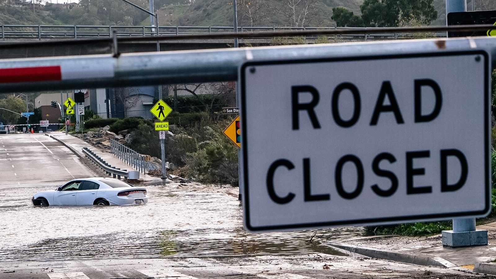
San Diego County woke to a new year marked by severe flooding and swift-water rescues after a powerful storm system swept through Southern California on January 1, 2026. The deluge, which broke century-old rainfall records, disrupted daily life and left authorities bracing for continued weather threats.
Historic Rainfall Engulfs San Diego
The storm delivered a relentless downpour across the region, with San Diego International Airport measuring 2.07 inches of rain on New Year’s Day—a figure not seen since the previous record of 1.60 inches set in 1855. Other communities, including Chula Vista, El Cajon, Lake Cuyamaca, and Campo, saw similar historic numbers, but Palomar Mountain stood out, receiving over five inches in just 24 hours. National Weather Service meteorologist Philip Gonsalves characterized the more than two inches falling within 12 hours in many areas as “pretty remarkable,” underscoring the rarity of such an event.
For residents, the sudden intensity caught many off guard. Streets quickly became rivers, with water pouring into low-lying neighborhoods and commercial centers. Downtown San Diego, Mission Valley, Alpine, Poway, and Escondido all reported significant inundation, leaving motorists stranded and homes threatened.
Swift-Water Rescues Amid Rising Floodwaters
Emergency crews worked non-stop throughout the day, responding to calls for help as floodwaters overwhelmed local infrastructure. In Escondido, a woman was swept into a creek feeding Lake Hodges while attempting to cross a low-water area with her husband. Quick action by the San Diego County Fire-Rescue team resulted in her rescue and safe transport to a hospital; both individuals were reported in stable condition.
Mission Valley saw its own drama unfold beneath a bridge near State Route 163, where lifeguards pulled a man from waist-high water as the San Diego River surged. He was hospitalized with non-life-threatening injuries. At Fashion Valley Mall, rising floodwaters trapped an adult and a child inside their vehicle. Lifeguard swift-water teams navigated treacherous currents to bring them to safety, with San Diego Fire-Rescue Department spokeswoman Candace Hadley likening the scene to “a river” coursing through the mall’s Avenida Del Rio area.
These rescues highlighted the risks posed by fast-moving floodwaters and the preparedness of local emergency services. The incidents also served as a stark reminder of the unpredictability of extreme weather, especially when record rainfall arrives in a matter of hours.
Infrastructure Struggles and Community Response
The flooding’s impact rippled across San Diego’s transportation network, halting trolley service in the downtown area for several hours. Commuters and businesses faced delays as crews worked to clear submerged tracks and restore operations. Meanwhile, the city activated its inclement weather shelter program for a second consecutive day, opening additional beds for those most vulnerable to the elements. Normally reserved for colder months, the program responds to severe conditions like those seen on New Year’s Day, when more than an inch of rain fell in under 24 hours.
Local officials urged caution and patience as recovery efforts got underway. The National Weather Service maintained a beach hazards statement through Sunday morning, warning of minor tidal overflow and localized beach flooding—especially as further rain was forecast. Temperatures were expected to remain in the 60s, but colder and weaker systems would bring intermittent showers into the middle of next week.
The broader outlook included a Level 1 out of 4 flash flood risk along the California coastline from Friday to Monday, with pockets of Level 2 risk in Northern and Southern California on Saturday, particularly in mountainous areas near Los Angeles. Forecasters predicted more rain on Sunday, with the possibility of 2.5 feet of inundation—a level not seen since 1998, according to Fox Weather and the National Weather Service.
Public Safety and Future Risks
With conditions still hazardous, authorities issued clear guidance: avoid walking, swimming, or driving through flooded streets. The San Diego County Sheriff’s Office emphasized that “just six inches of fast-moving water is enough to put your life at risk. Remember, turn around, don’t drown.” This message echoed across local media as officials sought to minimize further incidents and injuries.
The city’s response will be tested further as additional storms approach, but the events of New Year’s Day have already prompted discussions about urban resilience, emergency preparedness, and the vulnerability of aging infrastructure. Community organizations and city departments continue to monitor the situation and provide resources to those affected, while meteorologists warn that changing climate patterns could mean such events become less rare in the future.
Based on the presented facts, San Diego’s experience on New Year’s Day 2026 underscores both the immediate risks of extreme weather and the critical importance of rapid emergency response. The historic rainfall and subsequent flooding reveal vulnerabilities in local infrastructure, highlighting the need for continued investment in preparedness and adaptation as climate variability intensifies.