
Quick Read
- Tropical Storm Erin is expected to strengthen into a hurricane by August 14 and a major hurricane by August 17.
- The storm is currently moving westward at 23 mph with sustained winds of 45 mph.
- Uncertainty remains about Erin’s long-term path, with risks to the Caribbean and U.S. East Coast.
- Residents are urged to prepare for potential impacts, including rough seas and dangerous rip currents.
- Environmental factors, such as warm waters and low wind shear, favor Erin’s rapid intensification.
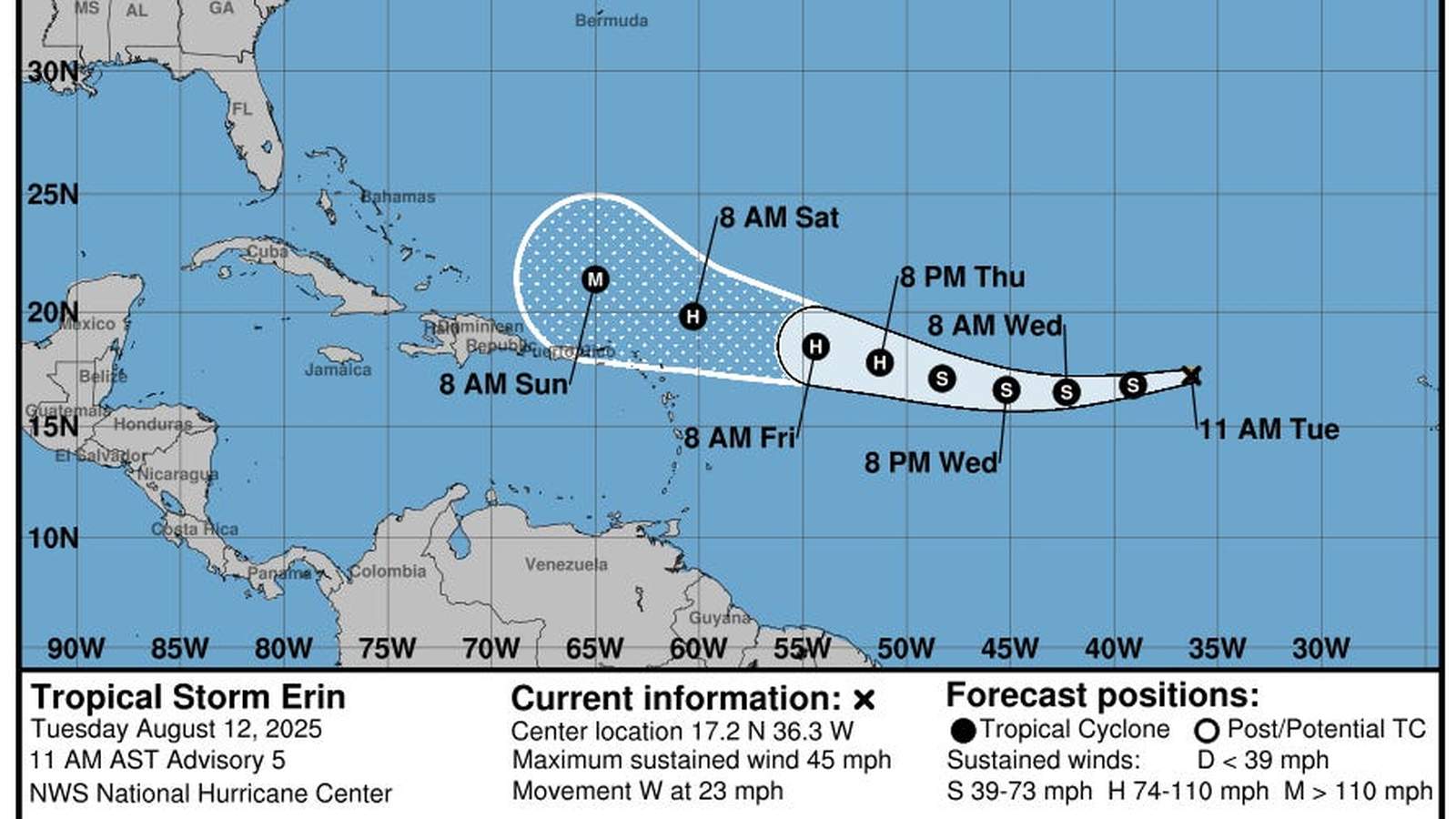
Tropical Storm Erin is rapidly intensifying as it races westward across the Atlantic Ocean, setting the stage to become the first major hurricane of the 2025 Atlantic hurricane season. According to the National Hurricane Center (NHC), Erin is projected to reach hurricane strength by late Thursday, August 14, and could escalate into a Category 3 hurricane or higher by early Sunday, August 17.
Current Path and Forecast
As of the latest advisory, Tropical Storm Erin is located approximately 820 miles west of the Cabo Verde Islands, moving west at 23 mph. The storm’s maximum sustained winds are currently at 45 mph, but it is expected to strengthen significantly as it encounters warmer waters and favorable atmospheric conditions, such as low wind shear. The NHC forecasts that Erin will turn west-northwestward later this week, potentially steering northward by early next week.
Forecasters have noted that the storm’s trajectory is still uncertain. While most models predict Erin will stay over open waters, there is an increasing risk that it could approach the northern Leeward Islands, Virgin Islands, and Puerto Rico over the weekend. According to USA Today, the precise impact on these areas and the U.S. East Coast will depend on how Erin interacts with the Bermuda High pressure system and an approaching jet stream dip.
Potential Impacts and Preparations
Although no coastal watches or warnings have been issued yet, meteorologists are urging residents in the Caribbean and along the U.S. East Coast to remain vigilant. Even if Erin does not make landfall, it is likely to generate rough seas, dangerous rip currents, and heavy surf along the coast. AccuWeather experts have also warned of potential squalls and rough surf in Puerto Rico and Hispaniola.
Given the peak of the hurricane season, officials are encouraging residents to prepare now. The National Oceanic and Atmospheric Administration (NOAA) advises stocking up on disaster supplies, reviewing evacuation plans, and ensuring adequate insurance coverage. “Delaying preparations could mean waiting until it’s too late,” NOAA emphasized.
Environmental Conditions Favoring Intensification
According to meteorologists, several factors are contributing to Erin’s rapid strengthening. The storm is moving through an area with warm sea surface temperatures exceeding 80°F and minimal wind shear, both of which are conducive to hurricane development. Additionally, the absence of Saharan dust in the atmosphere is allowing Erin’s convection to strengthen without interference.
The storm’s diameter has already reached over 650 miles, making it one of the largest systems of the season thus far. “Erin could become a very large storm, with significant impacts even if it remains offshore,” noted CBS Miami.
Historical Context
Erin is the fifth named storm of the 2025 Atlantic hurricane season, forming earlier than the historical average of August 22. The first hurricane of the season usually forms by August 11, while the first major hurricane typically does not occur until September 1. This year’s accelerated activity underscores the importance of vigilance during what is expected to be an active hurricane season.
Interestingly, Erin’s development comes alongside other weather phenomena, including a non-tropical system near Nova Scotia and Hurricane Henriette in the Pacific. However, neither of these systems currently poses a threat to land.
As Erin continues to gather strength and move across the Atlantic, the coming days will be critical in determining its ultimate path and potential impacts. Residents in vulnerable areas are urged to stay informed and prepared.