


A Shift in Global Cartography
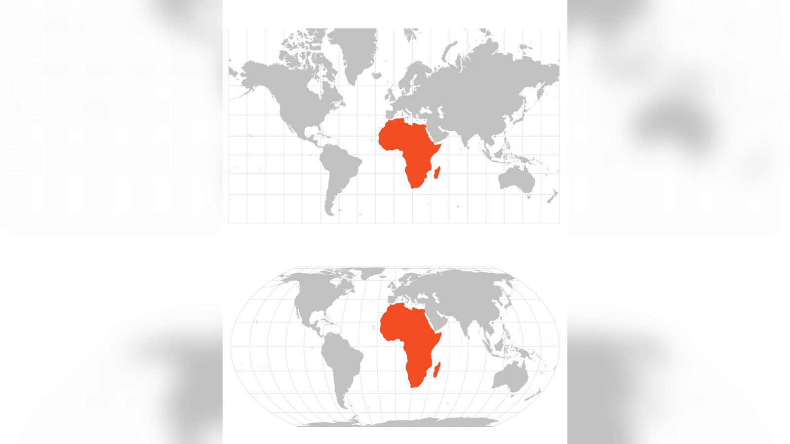
The United Nations General Assembly officially endorsed a new world map on Friday, aiming to address long-standing concerns regarding the geographic representation of the African continent. In a resolution sponsored by Togo and supported by the African Union, 164 member states voted to encourage the global adoption of the “Equal Earth” projection. This move seeks to replace the 16th-century Mercator projection, which critics have long argued systematically distorts landmasses by enlarging regions near the poles while shrinking those near the equator.
The vote marks a significant milestone for advocacy groups, including #CorrectTheMap and Africa No Filter, who have campaigned for years to change how the world visualizes geographic proportions. While the resolution is non-binding, it signals a shift in institutional norms for educational materials, textbooks, and digital platforms.
This report draws on information published by BBC.
The Distortion of the Mercator Map
Designed in 1569 by Flemish cartographer Gerardus Mercator, the traditional map was primarily intended as a navigational tool for maritime explorers. By accounting for the Earth’s curvature on a two-dimensional plane, the projection prioritizes navigational accuracy at the cost of proportional truth. As a result, Greenland and Africa appear roughly equal in size on standard maps, despite Africa being approximately 14 times larger in reality.
According to Syracuse University professor Mark Monmonier, the Mercator projection’s utility is strictly limited to maritime navigation. “Outside of that very narrow navigation application, there is no point in using it,” he noted. Modern geographers emphasize that the 2018 Equal Earth projection provides a more scientifically accurate representation of the globe’s surface, allowing for a more balanced view of continents.
Diplomatic Stakes and Opposition
The resolution passed with overwhelming support, including from France and the UK, though it faced notable dissent. The United States was the only nation to vote against the measure. Six countries—Serbia, Estonia, Georgia, Lithuania, Moldova, and Ukraine—abstained. During the proceedings, the US delegation expressed skepticism regarding the assembly’s focus, suggesting that the body should prioritize issues of international peace and prosperity over 16th-century cartographic projects.
Togolese Foreign Minister Robert Dussey, a primary architect of the resolution, emphasized the symbolic importance of the update, stating, “Maps shape our understanding of the world. They guide education, nourish the imagination, and influence collective perceptions.” French Foreign Minister Jean-Noël Barrot echoed this sentiment, remarking on social media that correcting a distorted representation is an “act of truth.”
Next Steps for Institutions
The resolution does not mandate a legal ban on the Mercator projection, but rather encourages a transition. Organizations and governments are now expected to consider the Equal Earth map for official publications and digital interfaces. For African nations, this is viewed as a necessary step to overcome what campaigners describe as “cognitive justice” issues, where the perceived scale of a region impacts its perceived economic and political significance. As the world moves toward more digitized and data-driven representations, the move toward the Equal Earth projection represents a broader effort to align visual information with geographic reality.