


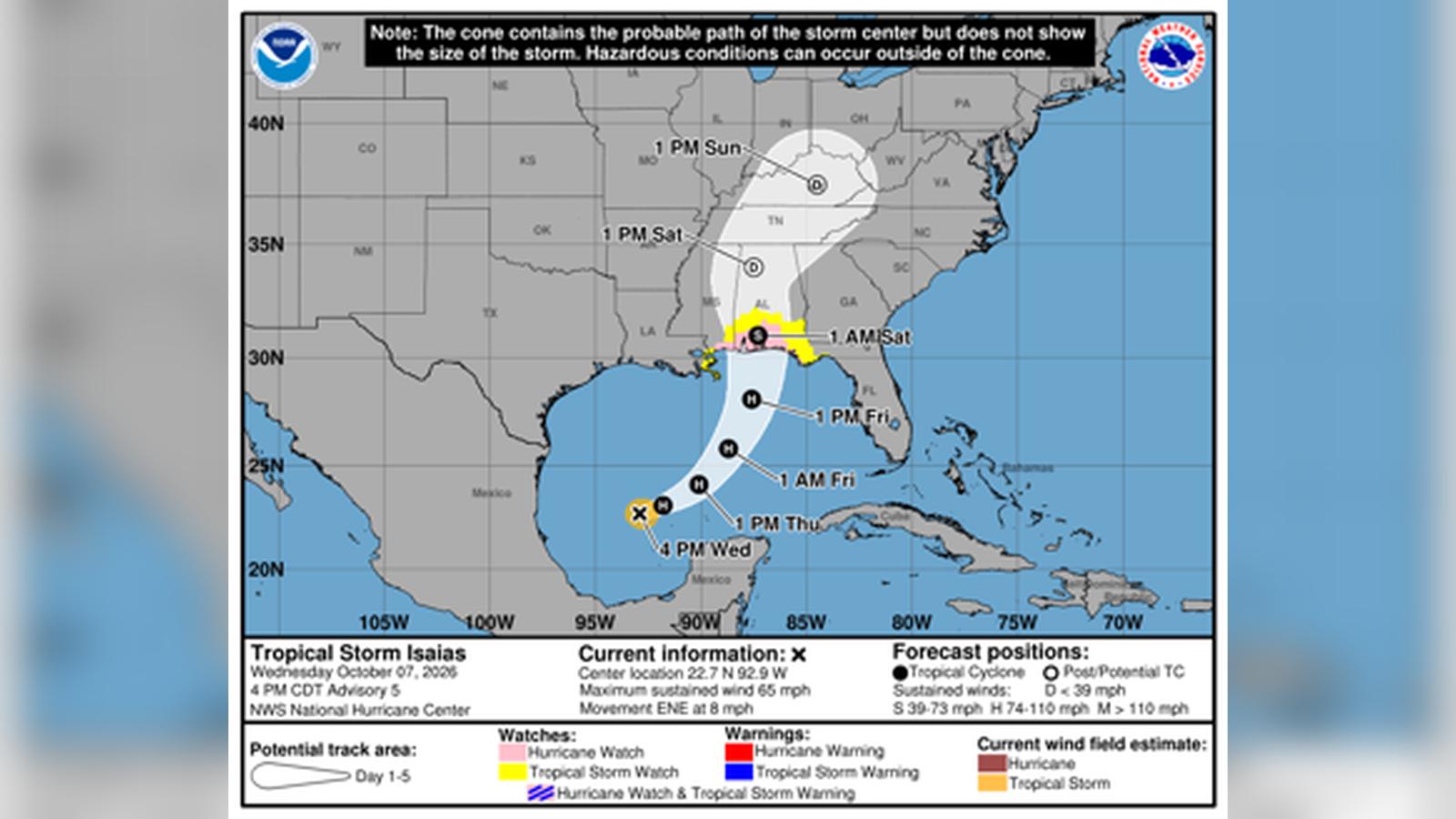
Forecasters report that Tropical Storm Isaias is rapidly strengthening in the southwestern Gulf of Mexico and is projected to strike the northern U.S. Gulf Coast as a Category 1 or 2 hurricane by late Friday or early Saturday. According to the Sun Sentinel, the system reached maximum sustained winds of nearly 70 mph by late Wednesday, moving east-northeast at roughly 9 mph. If Isaias achieves hurricane status by Thursday morning as expected, it would tie a 121-year-old record for the latest-forming initial hurricane in the Atlantic season, matching a benchmark set on October 8, 1905.
Watches, Warnings, and Projected Path
The National Hurricane Center has issued hurricane warnings stretching from Ocean Springs, Mississippi, to the Bay-Gulf County Line in Florida. A tropical storm warning is also in effect from west of Ocean Springs to the Jefferson-Plaquemines Parish Line. Forecasters explain that the storm’s track shifted slightly eastward through Wednesday, with landfall currently projected near the Alabama-Florida border.
As the system moves through the central Gulf, maximum winds are expected to peak at around 110 mph late Friday before vertical wind shear knocks the system down to an 85 mph Category 1 hurricane at landfall. Despite the weakening winds before impact, meteorologists warn that Isaias will interact with a short-wave trough, expanding its wind field and broadening the scope of potential damage.
Storm Surge and Regional Risks
Coastal residents from Louisiana to the Florida Panhandle face severe weather threats, including heavy rainfall, flash flooding, and life-threatening storm surges. According to updates reported by NOLA.com, the worst of the storm surge is anticipated to reach between 5 and 7 feet east of Ocean Springs, Mississippi, while areas to the west could see surges of 3 to 5 feet.
Rainfall totals are expected to range between 3 and 6 inches across the central Gulf Coast from Friday through the weekend, with isolated areas receiving up to 10 inches. Local emergency officials advise residents in vulnerable coastal zones to monitor advisories closely as the storm progresses toward the shore.
Colorado State University hurricane expert Phil Klotzbach noted that the overall season has been unusually quiet due to the influence of El Niño, which typically increases wind shear in the Caribbean and curtails Atlantic basin activity. However, Lindsey Long, a meteorologist with the National Oceanic and Atmospheric Administration’s Climate Prediction Center, cautioned that the wind shear in the Gulf has weakened relative to other regions, creating conditions favorable for late-season development. Long emphasized that it only takes one storm to produce significant destruction, urging populations along the coast to remain vigilant.
The system is the ninth named storm of the 2026 Atlantic hurricane season. Prior to this system, none of the season’s named storms had reached hurricane strength, making Isaias a notable anomaly in an otherwise subdued year. Historical data from the National Weather Service indicates that during the modern satellite era beginning in the mid-1960s, no year has passed without at least one hurricane forming in the Atlantic basin.
As Isaias tracks north and northeast, local meteorological offices in areas such as the Florida Panhandle have warned of potential structural damage to buildings, mobile home impacts, scattered power outages, and impassable roads due to debris. Emergency management agencies across southeastern Louisiana, coastal Alabama, and western Florida continue to coordinate preparedness efforts as the system draws closer to landfall.