


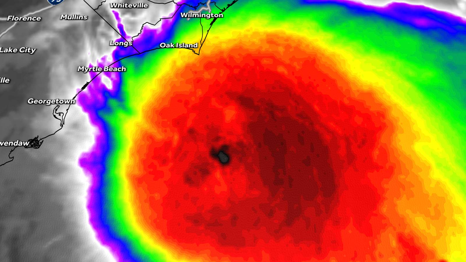
Tropical Storm Chantal made landfall early on Sunday, July 6, 2025, near Litchfield Beach, South Carolina, with sustained winds of 40 mph and gusts reaching up to 57 mph. As the storm progressed inland, it brought heavy rainfall, flash flood risks, and rough surf conditions, significantly impacting coastal and inland areas of both South and North Carolina.
Landfall and Initial Impact
According to the National Hurricane Center, Chantal made landfall around 4 a.m. with its center located approximately 15 miles northwest of Conway, South Carolina. The storm began forming near the coast of Georgia and Florida earlier in the week, intensifying briefly over the warm waters of the Gulf Stream. By the time it reached the Carolinas, tropical-storm-force winds extended up to 115 miles from its center. Coastal areas such as Myrtle Beach, South Carolina, and Oak Island, North Carolina, experienced high waves of 8-10 feet before the storm came ashore.
Speaking to WXII 12 News, meteorologist Dylan Hudler described the scene at Myrtle Beach as “an angry Atlantic Ocean” with palm trees bending under gusts of 40-50 mph. The storm’s minimal wind impact was overshadowed by the heavy rainfall, which posed a more significant threat as the system moved inland.
Heavy Rain and Flood Risks
The primary concern with Tropical Storm Chantal was not the wind, but the torrential rain it carried. Rainfall totals of 1 to 3 inches were forecasted for much of central and eastern North Carolina, with localized amounts potentially exceeding these estimates. The Piedmont Triad region, including Greensboro and Burlington, was identified as a high-risk area for flash flooding due to the heavy rainbands wrapping around the storm’s center.
In its advisory, the National Hurricane Center warned of flash flooding in low-lying areas, particularly in regions with poor drainage. “Rising creeks, streams, and ponding on roads could disrupt travel and pose safety risks,” the advisory stated. Flash flood warnings were issued for New Hanover, Brunswick, and Pender counties in North Carolina, where the storm’s effects were most pronounced.
Local meteorologists from WESH highlighted the storm’s slow northwest movement at 8 mph, which prolonged the rainfall in affected areas. “The storm’s sluggish pace increases the risk of prolonged flooding, especially in areas already saturated from previous rains,” reported the station.
Coastal and Inland Preparations
Coastal communities in South Carolina and North Carolina braced for the storm’s arrival by issuing warnings about dangerous surf and rip currents. The National Hurricane Center’s Storm Surge Unit also noted the potential for coastal flooding of up to two feet in vulnerable areas. Beachgoers from Charleston to the Outer Banks were advised to stay vigilant, although officials reassured that conditions would improve by Monday.
Inland, preparations varied as the storm’s track became clearer. Cities like Raleigh and Fayetteville prepared for scattered showers and isolated flooding, while areas farther west, such as Winston-Salem, anticipated less severe impacts. Emergency services in both states remained on standby to respond to potential flash flooding and other storm-related incidents.
Star News Online reported that power outages were limited but not entirely avoidable, as falling branches and saturated soil caused occasional disruptions. Utility companies worked proactively to address outages and clear debris.
Forecast and Long-Term Outlook
As of Sunday evening, Tropical Storm Chantal was expected to weaken into a tropical depression and eventually dissipate as it moved northeast toward the Mid-Atlantic region. By Monday, the remnants of the storm were forecasted to exit into the Atlantic Ocean, bringing an end to its immediate impacts on the United States.
This storm marks the third named system of the 2025 Atlantic hurricane season, which runs from June 1 to November 30. Earlier in the season, Tropical Storm Andrea and Tropical Storm Barry formed but caused minimal damage. Meteorologists from KTEN noted that Chantal serves as a reminder of the importance of early preparedness during hurricane season.
Tropical Storm Chantal may not have brought catastrophic damage, but its heavy rains and flash floods underscore the persistent risks posed by tropical systems during hurricane season. As communities recover, the focus now shifts to readiness for future storms in the months ahead.